The Occasional Blog of Author Cicely Rude

August 22, 2012

Recharging at Sea Ranch, California

Sea Ranch view of the Pacific Ocean
There is a planned, unincorporated community about half-way up the California coast called The Sea Ranch. Dating back to the lat 1960s, it's 16.2 square miles of coastline along California's famous Highway One in Sonoma County, just south of the tiny town of Gualala, CA. Today, it's the perfect location for a relaxing northern California coastal getaway. I spent a week there this summer relaxing and recharging before gearing up for a fall season of consulting work and book manuscript deadlines.

When to Go:

The Sea Ranch is beautiful at any time of year, but September and October offer the possibility of viewing Humpback and other whales from the shore as they migrate south for the winter.

Where to Stay:
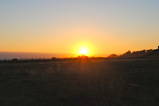
Sunset on the Sea Ranch
Many Sea Ranch homes are available for vacation rentals. Some are offered for rent by the owners, while others are available through real estate agencies based in Gualala. I made my recent reservations through Ocean View Properties and found their service friendly.

Points of Interest:

The Sea Ranch architecture is distinctively woodsy and designed to blend in with the surroundings. Also, the Sonoma County Regional Parks Department provides coastal access from six places along State Route 1 in the Sea Ranch area:
  • Black Point (trail) at 35035 State Route 1
  • Gualala Point Regional Park at 42401 State Route 1
  • Pebble Beach (trail) at 36448 State Route 1
  • Shell Beach (trail) at 39200 State Route 1
  • Stengel Beach (trail) at 37900 State Route 1
  • Walk On Beach (trail) at 40101 State Route 1
Advisories:
  • Be advised that the climb down to Stengel Beach is steep and involves climbing/sliding over a large boulder. Visitors with limited mobility may find it inaccessible.
  • This is tick-country, so I checked my dog carefully each day.

July 27, 2012

The Night Typhoon Bart Swept Across Japan

Does anyone recall Typhoon Bart? It swept across Japan back in the late summer/early fall of 1999. At that time, I had just joined the JET program as an Assistant Langauge Teacher (ALT) and moved into a little seaside apartment in the fishing town of Ushibuka, at the southernmost tip of Japan's Amakusa Island chain. A couple of years later, I wrote about the experience for the Record, a central California newspaper. More than ten years later, the article is still archived on the Record's website.

The whole article can be read for free at Recordnet.com. The 20120-13 JET Programme participants are landing in Tokyo about now, so if you are a new JET headed to Kumamoto Prefecture, particularly the Amakusa Islands, I encourage you to read this story. It's a tale of fear (yeah, this California native had never experienced a typhoon before), of truly functional architecture, and of inspiration. I remember feeling completely in awe of the collaborative spirit with which everyone in Ushibuka pitched in to clean up the town after Typhoon Bart churned up the sea and dumped mud all over the roads. It was eye-opening to see how powerful communities of people can be when everyone works together for the common good.

March 09, 2012

Marin Headlands

This is one of my favorite spots in the Marin Headlands. This cliff is part of the Golden Gate Nature Recreation Area that looks out on the Pacific Ocean. Tennessee Beach is in the foreground and The Golden Gate Bridge and city of San Francisco are just south and can be seen in the distance. You can get to this spot by parking in the lot and walking about two miles along the trail through Tennessee Valley. Directions are below. The area is just 20 minutes north of San Francisco.


How to get there:


To Tennessee Valley from San Francisco

Go north on highway 101
Exit Mill Valley / Stinson Beach / Hwy. 1
Follow Shoreline Hwy. until you see the Tennessee Valley Road sign
The turn off will be on the left

To Tennessee Valley from the East Bay

Take 580 west to the Richmond / San Rafael bridge
Cross the bridge (toll this direction)
Take the second exit after the bridge, go through Larkspur and get on 101 south
Follow 101 south, Take the Mill Valley / Stinson Beach / Hwy. 1 exit
Follow Shoreline Hwy. until you see the Tennessee Valley Road sign, the turn off will be on the left

To Tennessee Valley from the North

Go south on highway 101
Take the Mill Valley / Stinson Beach / Hwy. 1 exit
Follow Shoreline Hwy. until you see the Tennessee Valley Road sign
the turn off will be on the left


January 13, 2012

Golden Gate

Here's a classic shot of driving across the Golden Gate Bridge, headed toward the gorgeous Marin Headlands. The views of San Francisco from the pullouts on the Marin side of the bridge are beautiful, but the traffic can be crazy. If you don't want to contend with long lines of cars, get there and enjoy the view of the city by the bay before 10AM.

Fortunately, there are plenty of transportation alternatives for visiting the Golden Gate Bridge. According to the Golden Gate Bridge Highway and Transportation District, "We strongly recommend using the other means of visiting the Bridge as described on this page. Parking is extremely limited at both the southeast and northeast visitor areas of the Bridge, and ongoing construction projects in the area may temporarily close roads leading to the Bridge." More information can be found on the district's website.